Macromegas #19 - United States: The Inevitable Empire
How the US Made the Most of Their Unique Territorial Potential
Hi friends,
Happy Monday!
How the US Made the Most of Their Unique Territorial Potential
I recently read this outstanding essay on the reasons why the US had such a tremendous territorial context advantage.
I had thought that they geographically had all the cards in hands to become *the* modern hyperpower, with 2 oceans, no neighbouring military threats, a vast territory, and natural resources.
If you compare with China for example, with a larger proportion of desert and mountains, many regional or even global threats nearby, and access to one ocean through a shallow contested sea, you can see the decks are not stacked the same way.
Even Russia is more challenged, the vastness of the territory and the harsh climate being a double-edged sword.
But this article develops this story in the most fascinating and educating way. It does look at how the US had a great head start with the uncomparable edge of the Greater Mississippi Basin. But it also explores how they made the most out of this territory, how they expanded their buffer zone and their zone of influence, and how they played their cards into controlling the only military navy worth looking at in our modern days.
A fundamental 40-page essay of which I summarised the most import points below.
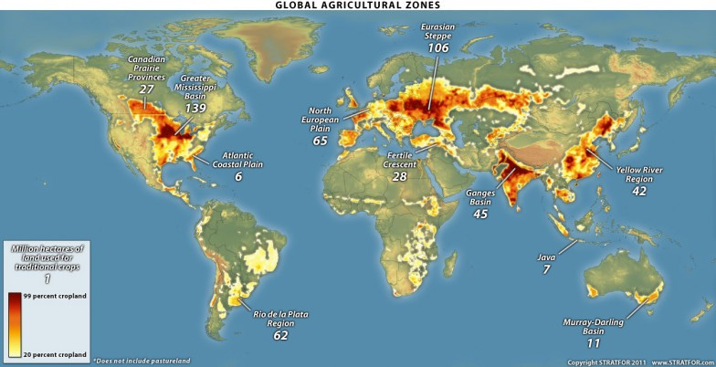
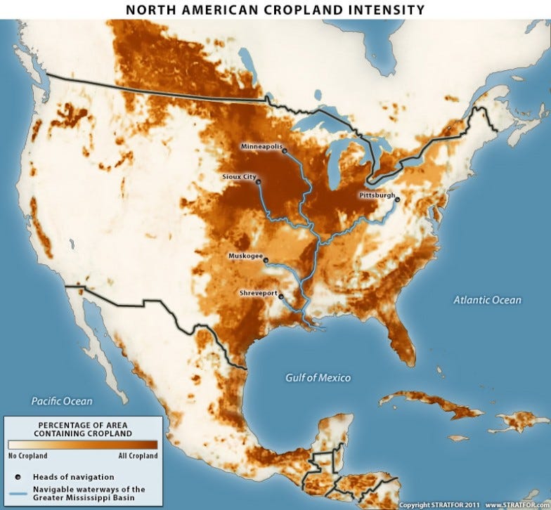
The American geography is an impressive one. The Greater Mississippi Basin together with the Intracoastal Waterway has more kilometers of navigable internal waterways than the rest of the world combined. The American Midwest is both overlaid by this waterway and is the world's largest contiguous piece of farmland. The U.S. Atlantic Coast possesses more major ports than the rest of the Western Hemisphere combined. Two vast oceans insulated the United States from Asian and European powers, deserts separate the United States from Mexico to the south, while lakes and forests separate the population centers in Canada from those in the United States. The United States has capital, food surpluses and physical insulation in excess of every other country in the world by an exceedingly large margin. So like the Turks, the Americans are not important because of who they are, but because of where they live.
0. The North American Core
All of the peoples of the [Mississipi] basin are part of the same economic system, ensuring constant contact and common interests. Regional proclivities obviously still arise, but this is not Northern Europe, where a variety of separate river systems have given rise to multiple national identities.
[...]
[On the superiority of] navigable rivers as opposed to coastlines. First, navigable rivers by definition service twice the land area of a coastline (rivers have two banks, coasts only one). Second, rivers are not subject to tidal forces, greatly easing the construction and maintenance of supporting infrastructure. Third, storm surges often accompany oceanic storms, which force the evacuation of oceanic ports. None of this eliminates the usefulness of coastal ports, but in terms of the capacity to generate capital, coastal regions are a poor second compared to lands with navigable rivers.
[...]
Thus, the Greater Mississippi Basin is the continent's core, and whoever controls that core not only is certain to dominate the East Coast and Great Lakes regions but will also have the agricultural, transport, trade and political unification capacity to be a world power — even without having to interact with the rest of the global system.
[...]
The early United States did not face any severe geographic challenges. The barrier island system and local rivers provided a number of options that allowed for rapid cultural and economic expansion up and down the East Coast. The coastal plain — particularly in what would become the American South — was sufficiently wide and well-watered to allow for the steady expansion of cities and farmland. Choices were limited, but so were challenges. This was not England, an island that forced the early state into the expense of a navy. This was not France, a country with three coasts and two land borders that forced Paris to constantly deal with threats from multiple directions. This was not Russia, a massive country suffering from short growing seasons that was forced to expend inordinate sums of capital on infrastructure simply to attempt to feed itself.
1. Dominate the Greater Mississippi Basin
There are only two ways to protect a coastal community from sea power. The first is to counter with another navy.
[...]
The second method of protecting a coastal community is to develop territories that are not utterly dependent upon the sea. Here is where the United States laid the groundwork for becoming a major power, since the strategic depth offered in North America was the Greater Mississippi Basin.
2. Eliminate All Land-Based Threats to the Greater Mississippi Basin
Story of how the US defused the Canadian threat by outgrowing them and isolating them from Britain
Story of how the US absorbed Texas to build a buffer against any threat towards New Orleans and the Greater Mississippi Basin
Story of how the US outgrew and overpowered Mexico, crushed them militarily, and imposed an easily enforceable border based on the Chihuahua Desert.
3. Control the Ocean Approaches to North America
The United States issued the Monroe Doctrine in 1823. It asserted that European powers would not be allowed to form new colonies in the Western Hemisphere and that, should a European power lose its grip on an existing New World colony, American power would be used to prevent their re-entrance. It was a policy of bluff, but it did lay the groundwork in both American and European minds that the Western Hemisphere was not European territory.
[...]
In 1898, the United States launched its first-ever overseas expeditionary war, complete with amphibious assaults, long supply lines and naval support for which American warfighting would in time become famous. In a war that was as globe-spanning as it was brief, the United States captured all of Spain's overseas island territories — including Cuba. Many European powers retained bases in the Western Hemisphere that could threaten the U.S. mainland, but with Cuba firmly in American hands, they could not easily assault New Orleans, the only spot that could truly threaten America's position. Cuba remained a de facto American territory until the Cuban Revolution of 1959. At that point, Cuba again became a launching point for an extra-hemispheric power, this time the Soviet Union. That the United States risked nuclear war over Cuba is a testament to how seriously Washington views Cuba. In the post-Cold War era Cuba lacks a powerful external sponsor and so, like Canada, is not viewed as a security risk.
[...]
Beset by a European continent fully under the control of Nazi Germany, London had been forced to concentrate all of its naval assets on maintaining a Continental blockade. German submarine warfare threatened both the strength of that blockade and the ability of London to maintain its own maritime supply lines. Simply put, the British needed more ships. The Americans were willing to provide them — 50 mothballed destroyers to be exact — for a price. That price was almost all British naval bases in the Western Hemisphere. The only possessions that boasted good natural ports that the British retained after the deal were in Nova Scotia and the Bahamas.
The remaining naval approaches in the aftermath of Lend-Lease were the Azores (a Portuguese possession) and Iceland. The first American operations upon entering World War II were the occupations of both territories. In the post-war settlement, not only was Iceland formally included in NATO but its defense responsibilities were entirely subordinated to the U.S. Defense Department.
4. Control the World's Oceans
The formation of NATO in 1949 placed all of the world's surviving naval assets under American strategic direction.
The inclusion of the United Kingdom, Italy, Iceland and Norway in NATO granted the United States the basing rights it needed to utterly dominate the North Atlantic and the Mediterranean — the two bodies of water that would be required for any theoretical European resurgence. The one meaningful European attempt to challenge the new reality — the Anglo-French Sinai campaign of 1956 — cemented the downfall of the European navies. Both London and Paris discovered that they now lacked the power to hold naval policies independent of Washington.
The seizure of Japan's Pacific empire granted the Americans basing access in the Pacific, sufficient to allow complete American naval dominance of the north and central portions of that ocean.
A formal alliance with Australia and New Zealand extended American naval hegemony to the southern Pacific in 1951.
A 1952 security treaty placed a rehabilitated Japan — and its navy — firmly under the American security umbrella.
5. Prevent any Potential Challengers from Rising
From a functional point of view the United States controls North America because it holds nearly all of the pieces that are worth holding. With the possible exception of Cuba or some select sections of southern Canada, the rest of the landmass is more trouble than it is worth. Additionally, the security relationship it has developed with Canada and Mexico means that neither poses an existential threat to American dominance. Any threat to the United States would have to come from beyond North America. And the only type of country that could possibly dislodge the United States would be another state whose power is also continental in scope.
[...]
Northern Eurasia holds even more arable land than North America, but it is split among three regions: the North European Plain, the Eurasian steppe and the Yellow River basin. Although the developed lands of the North European Plain and the Eurasian steppe are adjacent, they have no navigable waterways connecting them, and even within the North European Plain none of its rivers naturally interconnects.
There is, however, the potential for unity. The Europeans and Russians have long engaged in canal-building to achieve greater economic linkages (although Russian canals linking the Volga to the sea all freeze in the winter). And aside from the tyranny of distance, there are very few geographic barriers separating the North European Plain from the Eurasian steppe from the Yellow River region.
Thanks for reading,
V


Correction: Britain retained Newfoundland (including Labrador) until 1949, not Nova Scotia which joined the Canadian Confederation in 1867.